Archive for March, 2010

Recent updates in MapOSMatic

Saturday, March 20th, 2010
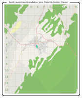
Saint Laurent en Grandvaux, Jura, Franche Comté, France

Saint Laurent en Grandvaux, Jura, Franche Comté, France

MapOSMatic recently passed an important milestone in its history. A few weeks ago, we served our 10,000th rendered map (Saint-Laurent-en-Grandvaux, Jura, France) ! We are very pleased with this accomplishment and feel it is important for us to continue improving the MapOSMatic service for our users. We are working on several objectives in parallel:

  • improving the user experience on the website, adding new features and more translations;
  • reducing the rendering latency to produce maps faster for our users;
  • improving the maps and indexes themselves.

Today we rolled out on MapOSMatic a few changes that have been brewing and undergoing extended testing on our development setup, and as I write this post I am pleased to see that we are making good progress on these three main directions.

First and foremost, I think the most important update today comes from the addition of a Spanish translation of the MapOSMatic website (and the corresponding capability to generate maps and indexes internationalized for Spanish-speaking countries), contributed by Julio Costa Zambelli, Sebastian Borgwardt and Jean-Guilhem Cailton. We hope the availability of MapOSMatic in Spanish will help the Chile earthquake disaster response teams.

Next, we restored the bounding-box area input fields for specifying an exact zone to render by the coordinates of its top-left and bottom-right corners. We also added a new feature to the slippy map: by maintaining the Control key pressed, you can draw a rectangle directly on the map to precisely define the limits of the area you wish to render!
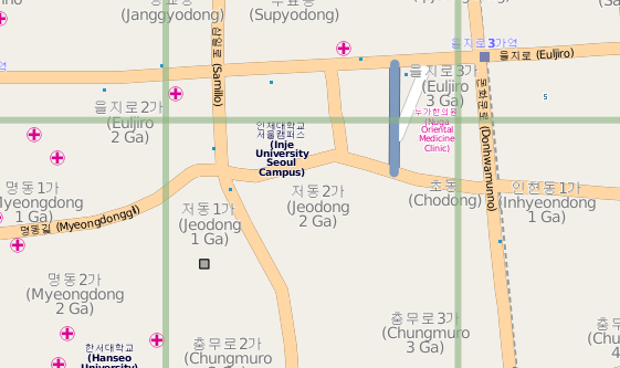
Small part of Seoul, South Korea

Small part of Seoul, South Korea

This update allows integrates better support for some languages :

  • The index of the streets and amenities, as well as the map and index titles are now rendered through the Pango library, which allows to correctly render Arabic, Korean or Japanese characters
  • The index is now rendered right-to-left for RTL languages such as arabic. The first column is on the right, the last column on the left, the street names are on the right while the square locations are on the left.
  • We also fixed a font problem with our Mapnik installation allowing for rendering of non-latin characters in the maps as well.
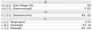
Small part of the index for Seoul, South Korea

Small part of the index for Seoul, South Korea

And finally, as advertised in a previous post about MapOSMatic improvements, we are now using a new version of the rendering daemon (the software in charge of processing the rendering requests queue and creating the maps and indexes). This new daemon lays the groundwork for future concurrent rendering and rendering jobs distribution which will help reducing the rendering latency, when completed. It also has better management of obsolete renderings, with the direct impact of no longer listing hundreds, if not thousands of maps we no longer have the rendered files for.

I would like to conclude this post by thanking, again, all the amazing contributors to MapOSMatic for their continuous feedback, ideas, bug reports and their celerity in providing translations updates when we add new features to MapOSMatic!

MapOSMatic talk proposal submitted for SOTM 2010

Monday, March 15th, 2010

State Of The MapState Of The Map is the yearly conference entirely dedicated to OpenStreetMap and is therefore the most important conference for the OpenStreetMap community. The 2010 edition will take place in Girona, Spain, from July, 9th to July 11th.

Maxime Petazzoni and I have submitted a talk about the MapOSMatic project, in the name of all the MapOSMatic developers. Our talk is entitled MapOSMatic: city maps for the masses, and here the abstract we’ve submitted :

Launched in september 2009, MapOSMatic is a web service that lets anyone create a map for any city in the world, based on OpenStreetMap data. A grid overlay is added to the map, along with the corresponding index of streets and amenities for the city, giving a ready-to-be-printed map. These maps can for example be used in information panels in cities, or, after folding, as traditional city maps.

As of march 2010, this service has generated over 10,000 maps, and has been adapted for French, English, German, Italian, Catalan, Russian, Arabic, Portuguese, Dutch, Crotian, Polish and Spanish.

Through our talk, we would like to highlight MapOSMatic history and features, give details on its technical implementation, describe the future directions we would like to take, and detail how the OpenStreetMap project as a whole could be improved to help projects such as MapOSMatic.

The presentation will be given by Maxime and Thomas Petazzoni, two geek brothers part of the team of french hackers who created and developed MapOSMatic. Maxime and Thomas both work in the embedded Linux area, respectively for Montavista Software, LLC and Free Electrons.

We hope that our proposal will be accepted so that we will be able to present the project to the wider OpenStreetMap community, gather ideas for improvements, and discuss how the OpenStreetMap project itself could be modified to better suit the needs of projects such as MapOSMatic. We’ll of course put an update on this blog as soon as we have the answer from the program comittee.

Two months of MapOSMatic improvements

Monday, March 8th, 2010

Since the december 2009 hackfest (reported here, here and here) and the official announcement of the improvements early january 2010, MapOSMatic has seen a sustained flow of interesting improvements. This post compiles the most important improvements that we have done recently, and some details on future improvements.

OcitySMap

Support for other countries has been added to OcitySMap, the Python module that actually generates the maps and the indexes. This support allows OcitySMap to generate correct indexes for other countries, by transforming street names such as “Calle de la Vida” into “Vida (Calle de la)”. This was made possible through the major re-organization of OcitySMap for internalization that took place during the december 2009 hackfest. So far, we have support for french, italian, spanish, catalan, brasilian portuguese, arabic, russian, dutch, crotian and polish, thanks to many contributors !

From a coding point of view, OcitySMap now uses the psycopg2 Python module to query the PostgreSQL database instead of pygresql. We made this change because Django, the Web framework that we use for MapOSMatic, already uses psycopg2. Using the same Python module to query the PostgreSQL database sounded like a logical choice.

MapOSMatic

MapOSMatic, the web front-end for OcitySMap, has also seen a large number of improvements. First, many translations have been added: german, italian, catalan, russian, arabic, brasilian portuguese, crotian, polish and dutch. For the Arabic translation, we have added Right-to-Left support in our web site design. Again, all the translations come from new contributors to the project.

The website has also been completely re-designed :

  • A brand new CSS, with a much cleaner design
  • The map creation page is now separate from the homepage, for more clarity
  • The selector for the city name in the map creation page now provides an auto-suggestion mechanism
  • The job and maps page have been completely re-designed, with a better design than the old table-based approach. The maps are now classified by first letter, and a search engine allows to quickly find existing maps.
  • A RSS feed has been added to keep track of map renderings taking place on MapOSMatic.org.

See Maxime Petazzoni’s blog post for details on these design improvements.

Coming improvements

We have already implemented further improvements, that are currently being tested on our development server :

  • A new rendering daemon. When a map request is entered on MapOSMatic, the map rendering doesn’t take place synchronously, since it is a quite consuming work. Map rendering requests are processed asynchronously, one after the other, through a daemon called maposmaticd. This daemon has been completely rewritten to use more Python-ic approaches, to better support timeouts (renderings taking too much time) and in the future to support parallel renderings.
  • Use of Pango for text rendering. Until now, OcitySMap was directly using Cairo for rendering text in the street index. While this was working fine for latin characters, it didn’t work for arabic or korean characters (and probably other non-latin characters). Therefore, we have rewritten the code that generates the index to use Pango on top of Cairo, so that all characters are properly rendered. This change needs a little more work but should be ready for production soon.

We have also identified one of the major reasons for which the rendering requests are sometimes so long to process. One of our geographic SQL query is taking a very long time, due to the absence of optimization. We are working on this issue with PostGIS/PostgreSQL experts, and hope to get down from 4 minutes 38 seconds for getting the list of streets for Toulouse to something around 3.2 seconds. As you can expect, we are really looking forward to making these new changes available to the MapOSMatic community!